Skip to content

Waypoint Journeys Presents

Lesotho

Nothing Below 1,400 Metres

12 Days

A Full Circuit of the Mountain Kingdom, Maseru to Maseru

12 DaysFrom $4,650 USDMax 5 guests

We reply within 24 hours

A Country That Starts Where Others End

Lesotho is the only country in the world with no land below 1,000 metres. Its lowest point, where the Senqu meets the Makhaleng, sits at about 1,400 metres, which is higher than the highest ground in a good many countries. Everything else goes up from there. It is enclosed on all sides by South Africa, it is roughly the size of Belgium, and almost none of it is flat.

What that produces is a country organised around passes rather than cities. You do not travel across Lesotho, you travel over it: the Moteng, the Mahlasela at 3,222 metres, the Mafika-Lisiu, the Blue Mountain, and the switchbacks below Sani Top where the Drakensberg drops away to KwaZulu-Natal in a single 1,300-metre step. Between them are villages of stone and thatch, herd boys in Seanamarena blankets on ponies, and a great deal of sky.

This circuit takes twelve days to close the loop from Maseru and back, clockwise around the highlands. It is not a hard trip in the way our West African convoys are hard: the tar is good on more than half the route, the lodges are comfortable, and nobody is crossing a border every second day. What it asks of you is tolerance for altitude, for cold at night in any month, and for a couple of gravel roads that take four hours to cover eighty kilometres because the country will not let you go faster.

"Ask a Mosotho where the mountains start and you get a puzzled look. There is nowhere here that is not the mountains."
Lesotho Maletsunyane Falls
The Maletsunyane Falls near Semonkong: 192 metres in a single drop

Five Passes, Two Dams and a Kingdom That Was Never Taken

The Only Country Entirely Above 1,000m

Lesotho's lowest ground sits at roughly 1,400 metres, the highest low point of any country on Earth. There is no lowland to pass through and no gentle approach. You land, and you are already higher than most people ever drive.

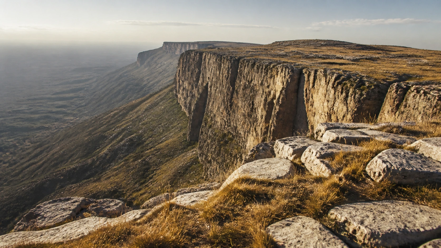
The Mahlasela Pass at 3,222m

The tar climbs out of Butha-Buthe over the Moteng, then keeps climbing to Mahlasela, one of the highest surfaced roads in Africa and the approach to Afriski, the continent's southernmost ski slope. We stop at the top because everybody does, and because the view earns it.

Maletsunyane, 192 Metres in One Drop

At Semonkong, the place of smoke, the Maletsunyane River goes over the lip in a single fall taller than any waterfall in southern Africa. There is a commercial abseil down the gorge wall beside it, one of the longest anywhere, and it is entirely optional.

Basotho Ponies

In much of the highlands the pony is still the vehicle, not the attraction. Out of Malealea we ride the working animals with the men who work them, at a walk, into a valley with no road into it. Guests who would rather not ride walk the same ground.

Thaba-Bosiu, the Mountain at Night

Moshoeshoe I moved his people onto this flat-topped hill in 1824 and held it against every force sent to take it. Lesotho exists as a country largely because that worked. We walk up the pass his warriors defended and stand where the nation was assembled.

Katse, and the Country That Sells Water

Lesotho's largest export leaves by tunnel. The Katse arch dam holds back 185 metres of the Malibamatso and sends it under the mountains to Gauteng. Standing on the wall, with the reservoir bending away into side valleys, explains more about this country than any museum.

The Expedition

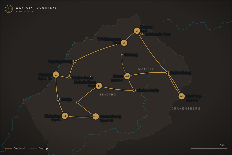
Twelve days clockwise around the highlands from Maseru: north to the passes, east to the escarpment, south through the dams, and back down to the ponies.

Day 1
Arrival Maseru

Arrive at Moshoeshoe I International, twenty minutes from the capital, or cross by road at Maseru Bridge if you are coming overland. Maseru is a low, sprawling town of about a quarter of a million people that most itineraries treat as a formality. We give it an evening: the Basotho hat building, a look at the blanket shops on Kingsway, and a route briefing over dinner.

Day 1 · 1,600m
Day 2
Thaba-Bosiu and Teyateyaneng, north to Ts'ehlanyane

We start at Thaba-Bosiu, the flat-topped mountain Moshoeshoe I fortified in 1824 and never lost, walking up the Khubelu pass with a guide from the village below. Then north on the A1 through Teyateyaneng, where the weaving co-operatives still work to order, and up into the Maloti to Ts'ehlanyane National Park for the night.

Day 2 · about 4 hours driving
Day 3
Ts'ehlanyane forest, the Moteng and Mahlasela passes

A morning walk into the che-che, a stand of indigenous woodland that survives in this one high valley and almost nowhere else in the country. Then the climb: Butha-Buthe, the hairpins of the Moteng Pass, and on to Mahlasela at 3,222 metres, where the road tops out and Afriski's slope sits improbably on the ridge. Night at Oxbow.

Day 3 · high point 3,222m
Day 4
Oxbow to Mokhotlong and up to Sani Top

East across the roof of the country, past the turnoff for Letseng, the highest working diamond mine in the world, and down into Mokhotlong, the last real town before the escarpment. In the afternoon we turn south for Sani Top and sleep on the rim at 2,874 metres, with the whole Drakensberg wall falling away below the windows.

Day 4 · about 5 hours driving
Day 5
The escarpment rim at Sani Top

A full day on the edge. We walk north along the rim toward Thabana Ntlenyana, at 3,482 metres the highest ground in Africa south of Kilimanjaro, going as far as the weather and the group want to go. Below the lip, the Sani Pass switchbacks drop 1,300 metres into KwaZulu-Natal. Afternoon in the village, evening at the pub that advertises itself as the highest in Africa.

Day 5 · walking, 4 to 6 hours
Day 6
Sani Top to Katse on the Linakaneng road

The hardest driving day and the best one. Back through Mokhotlong, then west on the gravel through Linakaneng: eighty kilometres that take most of the morning, through cattle posts, river crossings and villages where the road is also the main street. It comes out above the Katse reservoir in the late afternoon, and the water appears without warning.

Day 6 · gravel, 6 to 7 hours
Day 7
Katse Dam and the Mafika-Lisiu Pass to Bokong

The morning at the dam: the guided walk into the wall itself, 185 metres of double-curvature concrete, and the botanical garden that holds the plants rescued from the flooded valleys. Then up the Mafika-Lisiu Pass to Bokong Nature Reserve at just over 3,000 metres, where a short walk reaches the lip of the Lepaqoa gorge. Back to Katse for the night.

Day 7 · short driving day
Day 8
Katse to Thaba-Tseka, the Blue Mountain Pass and Mohale

South on the A8 to Thaba-Tseka, then west on the A3, the road that carries the finest sequence of passes in the country: the Blue Mountain, then Bushman's, then Molimo Nthuse, which translates roughly as God Help Me and was named by someone who had walked it. We stop at the Mohale Dam, the rockfill sibling of Katse, and stay the night above the water.

Day 8 · about 5 hours driving
Day 9
Mohale to Semonkong

A shorter, slower day south through Ramabanta on a road that keeps climbing and dropping between villages, with time to stop for the initiation-season blankets, the sandstone kraals and whatever is happening at the roadside. Semonkong sits at 2,275 metres at the end of it, a trading post where horses still outnumber cars on a Saturday.

Day 9 · about 3 hours driving
Day 10
Maletsunyane Falls and the Semonkong gorge

We ride or walk out to the falls in the morning, when the light is behind you and the spray column that gives Semonkong its name is at its highest. Anyone who wants to abseil the gorge wall does it today, 204 metres on a single rope, with the operator who has run it for years. Everyone else takes the path down to the plunge pool instead.

Day 10 · abseil optional, extra cost
Day 11
Semonkong to Malealea, an afternoon on horseback

Down out of the high country to Malealea, in the Makhaleng valley, arriving in time for the afternoon ride. The ponies are the ones the village works, the guides are the men who own them, and the route drops to a gorge and a set of rock paintings that has no road to it. There is a walking version of the same valley for anyone who prefers their own feet.

Day 11 · riding, 2 to 4 hours
Day 12
Malealea, Morija and departure Maseru

A last morning through the sandstone lowlands, stopping at Morija for the museum and archives, the oldest in the country, and the dinosaur trackways in the rock above the mission. Maseru is ninety minutes further on. We aim to have you at the airport or the border by early afternoon, so book onward flights from late afternoon.

Day 12 · about 3 hours driving
Lesotho Maloti Pass

Small Group Expedition

Every Detail Arranged.
Every Moment Yours.

What's Included

Duration12 days / 11 nights, a closed circuit from Maseru back to Maseru
Group SizeSmall group expedition: maximum 5 guests
TransportPrivate 4WD with a Mosotho driver-guide who runs these passes year round: daylight driving only
AltitudeEvery night between 1,600m and 2,874m: high point 3,222m at the Mahlasela Pass
AccommodationEleven nights in mountain lodges and guest houses: comfortable and heated, simple at Sani Top and Katse
Included ExperiencesThaba-Bosiu with a village guide; Ts'ehlanyane forest walk; the Katse dam wall tour and botanical garden; Bokong; the Maletsunyane Falls; a Malealea pony trek or valley walk; Morija Museum
MealsBreakfast and dinner daily, since most nights are at lodges with no alternative nearby: lunches on the road are your own
Not IncludedInternational flights, the Johannesburg to Maseru hop, travel insurance, the Semonkong abseil, lunches, and alcohol

FREQUENTLY ASKED QUESTIONS

Common Questions About This Expedition

Colder than most people expect from a country at this latitude, because altitude beats latitude here. We run the circuit in the shoulder months, and even then a night at Sani Top or Oxbow can drop below freezing while the same afternoon is warm enough for shirtsleeves. Snow falls on the high passes in any month and is normal from June to August. Summer days are mild but bring hard afternoon thunderstorms. You will want a real jacket, a hat and gloves, whatever the calendar says.
No. The Malealea day has a walking alternative to the same valley, and plenty of guests take it. If you do ride, the Basotho pony is a working animal bred for this terrain, sure-footed on ground that would worry a larger horse, and the pace is a walk. No previous riding is assumed. We offer a two-hour option and a longer half-day option, and you can decide on the morning rather than in advance.
Mixed, and that is the point. Much of the circuit runs on genuinely good tar: the A1 north, the A8 to Katse, the A3 over the Blue Mountain Pass. Two stretches are not. The Linakaneng road between Mokhotlong and Katse is gravel, slow and spectacular, and the last climb to Sani Top is a switchback track in a class of its own. We drive it in 4WD, in daylight, with a driver who runs these passes weekly.
Almost everyone arrives through Johannesburg. There is a short daily hop from Johannesburg to Maseru, or we can meet you at the border and drive you in, which many guests prefer to a 4am connection. Most Western passport holders enter Lesotho visa free for a short stay, but you will be transiting South Africa either way, so we confirm both sets of requirements for your specific nationality once you book.

Expedition Investment

$4,650USD

per person, twin share

Fully inclusive of the private 4WD and Mosotho driver-guide for twelve days, eleven nights' accommodation, breakfast and dinner daily, all park and reserve fees, the Katse dam wall tour, and the Malealea pony trek or valley walk

Excludes international flights, the Johannesburg to Maseru hop, travel insurance, lunches, alcohol and the optional Semonkong abseil. Single supplement $520 USD. Runs March–May and September–November; snow can close a pass at any time of year and the route adjusts around it

Reserve Your Spot
A Note on Safety & Logistics

Lesotho is a calm country to travel in, and the risks on this expedition are mountain risks rather than security ones: weather that turns in an hour, snow on a pass, altitude that leaves some people short of breath on the first two days, and roads where a recovery would take a while to arrive. We plan around all four. Every night is at a fixed, known lodge, we drive in daylight only, the vehicle carries recovery gear and a satellite communicator, and the driver-guide has the authority to reverse the day's route if a pass is closed or the cloud comes down. Guests with heart or lung conditions should talk to us before booking, because two nights are spent above 2,800 metres. We brief every confirmed traveller in detail before departure.