The Islands Most Visitors Never See
Most people who fly to Cabo Verde never leave Sal or Boa Vista. They land at a resort airport, spend a week on white sand in a hard trade wind, and go home thinking they have seen the country. What they have seen is two flat, dry islands that look nothing like the rest. The archipelago sits about 570 kilometres off the coast of Senegal: ten volcanic islands, nine of them inhabited, and the ones worth crossing an ocean for are the steep ones.
This guide is about those. Santiago, where the Portuguese built their first town in the tropics. Fogo, an active volcano with families farming inside its crater. Sao Vicente and the port of Mindelo, which gave the islands their music. And Santo Antao, a wall of green ravines an hour's ferry away. It covers how to move between them (the hard part), when to go, the entry rules that changed this year, and what it costs, from the team that runs our ten-day expedition from Praia to Mindelo.
How the Islands Fit Together
The islands fall into two groups. The Barlavento, or windward islands, run across the north: Santo Antao, Sao Vicente, uninhabited Santa Luzia, Sao Nicolau, Sal and Boa Vista. The Sotavento, the leeward group, lies to the south: Maio, Santiago, Fogo and Brava. Praia, the capital, is on Santiago. Mindelo, the second city, is on Sao Vicente, a little over 250 kilometres to the northwest.
Everything turns on flights and ferries, and both are thin. Domestic flights are small turboprops with few seats and schedules that move. The inter-island ferries publish timetables they do not always keep, and the open-sea crossings between the southern and northern groups can be long and rough. The one dependable link is Mindelo to Porto Novo on Santo Antao, about an hour, with sailings most days in the morning and afternoon. Santo Antao has no working airport, so that ferry is the only way in. Our rule: choose three or four islands, book the domestic legs the day you book your international flights, and build slack in at both ends.
Santiago: Praia and Cidade Velha
Praia sits on a flat-topped headland above the harbour. The Plateau quarter holds the colonial grid, the presidential palace and the main church, and the streets below it hold the Sucupira market: loud, crowded, and the best place to see what the country actually eats, wears and argues about. Half a day is enough.
About 15 kilometres west along the coast is Cidade Velha, the original capital, founded by the Portuguese in 1462 as Ribeira Grande. It was the first European colonial town in the tropics and, for well over a century, a hub of the Atlantic slave trade. UNESCO listed it in 2009. The stone pillory in the square, the pelourinho, dates from the early 1500s and was used to punish enslaved people in public. Up the slope are the ruins of the cathedral, and on the ridge above stands the Fortaleza Real de Sao Filipe, built after Francis Drake sacked the town in 1585. From the fort you can see the whole story at once: the anchorage, the narrow valley the town was squeezed into, and why the capital eventually moved up to the more defensible plateau at Praia.
Fogo: A Night Inside the Volcano
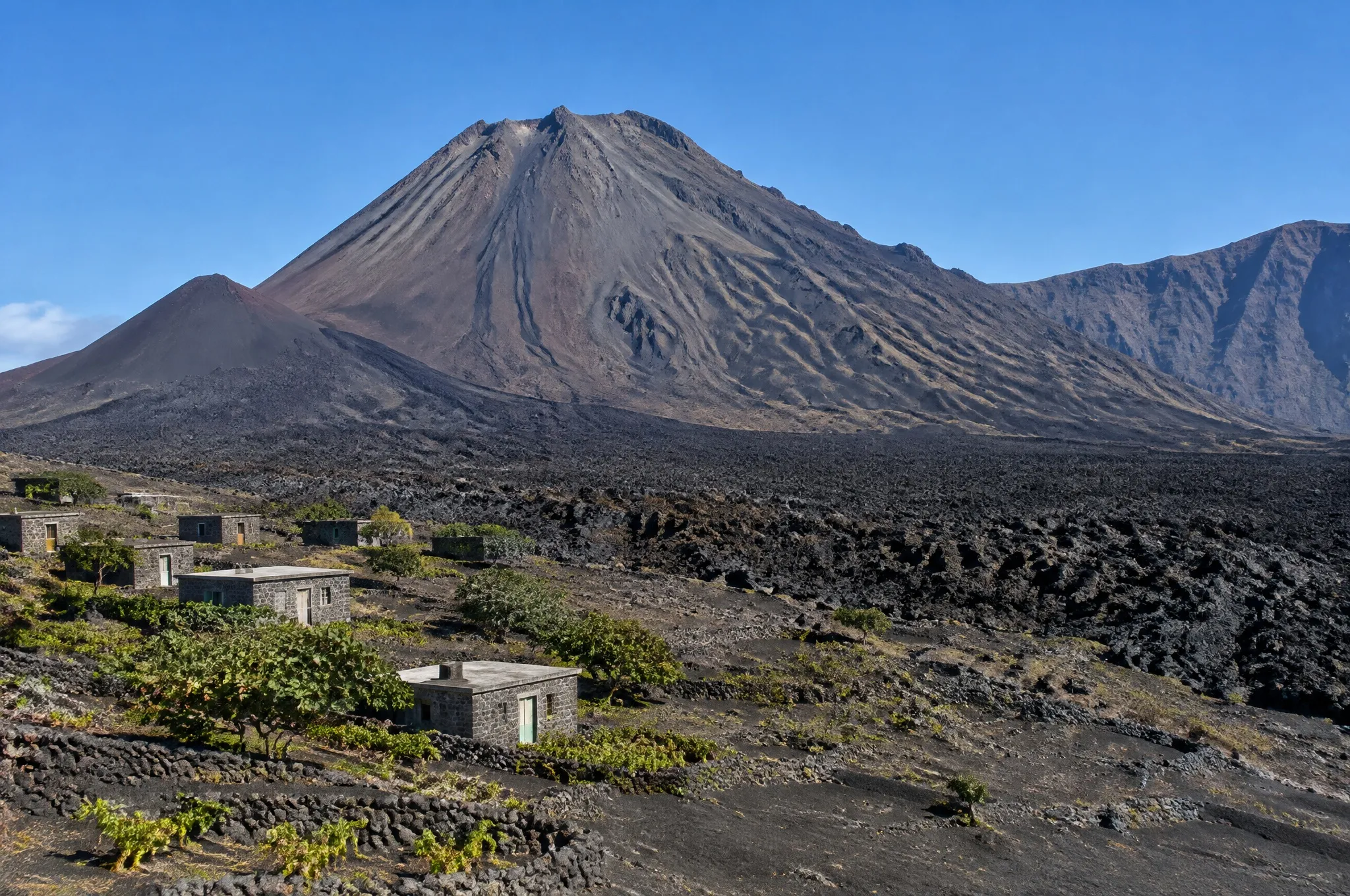
Fogo is the reason to make this trip. The island is one volcano rising straight out of the sea, and its summit, Pico do Fogo, reaches 2,829 metres, the highest point in the country. The old summit collapsed long ago and left a caldera roughly nine kilometres across, walled on the west by cliffs close to a kilometre high. On the caldera floor, at Cha das Caldeiras, about 1,700 metres up, families grow vines, coffee and fruit trees in black ash.
They have kept doing it through eruptions in 1951, 1995 and 2014. The last one began in November 2014 and ran into February 2015, and its lava buried most of the villages of Portela and Bangaeira, along with the wine cooperative and the park headquarters. Most families came back and rebuilt, some directly on the new flow. A night with them, in a simple family guesthouse, is the heart of any good Fogo trip. Drink the local wine, made from grapes including the manecom variety, and the coffee grown in ash on the slopes.
The summit climb starts in the dark, around four or five in the morning, with a local guide. It is about 1,100 metres of ascent on loose rock and ash and takes three to four hours to the crater rim, depending on your legs. The descent is the fun part: a long scree slope you half-run, half-ski down in your boots in under an hour. It is steep and tiring rather than technical, but it is not a walk to attempt unfit. If the summit is too much, Pico Pequeno, the cone left by the 1995 eruption, makes a shorter outing among the same strange colours.
Sao Filipe, the island's town, deserves a night on either side of the crater. It is a clifftop grid of sobrados, the two-storey merchant houses with wooden balconies, with a black-sand beach far below that is beautiful to look at and dangerous to swim from.
Mindelo and the Music
Mindelo grew up around Porto Grande, a deep natural harbour that became a coaling station for British steamships in the nineteenth century. That traffic gave the town its outward-looking streak, its pastel colonial facades and its music. Morna, the slow, aching song form of the islands, is played everywhere in Cabo Verde, but Mindelo is where it filled the bars along the waterfront, and where Cesaria Evora sang it barefoot for decades before the rest of the world noticed. UNESCO added morna to its intangible heritage list in 2019.
The evenings are the point. Several restaurants and bars have live music most nights of the week, and an evening of morna and coladeira in a small room is worth planning a day around. By day, walk the waterfront, the fish market and Rua de Lisboa, and on a clear day drive up Monte Verde, at about 750 metres, for the view back over the bay. February brings Carnival, which Mindelo takes very seriously, and August brings the Baia das Gatas music festival. Book well ahead for either.
Santo Antao on Foot
The ferry lands at Porto Novo, which is dry and brown, and for the first few kilometres you will wonder what the fuss is about. Then the Estrada da Corda, a cobbled road laid by hand over the mountains, climbs through pine and eucalyptus to the ridge, and the north side of the island opens below you: ravines close to a kilometre deep, terraced to the last metre with sugarcane, bananas, cassava and yams. Stop at Cova, an old crater with a farmed floor, and look down into the Paul valley from its rim.
This is a walking island, and the trails are old stone mule paths that linked the villages long before the roads did. The classic is the descent from Cova into Paul, roughly a thousand metres down on steps and switchbacks past small farms and grogue distilleries. Grogue is the island's sugarcane spirit. The cane is crushed in a trapiche, a few of them still turned by oxen, and distilled in copper, mostly for drinking in the valley rather than for export.
The other essential walk is the coastal path from Ponta do Sol to Fontainhas, a village stacked along a ridge above the sea, and on to Cruzinha. The path is cut into the cliff with real drops in places, so it suits people who are steady on their feet. Any of these walks can be swapped for a drive if knees or weather say no.
When to Go
Cabo Verde is warm and dry all year, with daytime temperatures in the mid-twenties Celsius at sea level and much cooler air in the Fogo caldera and on the Santo Antao ridges. What rain there is falls mostly between August and October, in short bursts, and some years it barely comes at all. From about November to March the harmattan blows Saharan dust out over the Atlantic, and the islands can sit under a pale haze, the bruma seca, that flattens views and occasionally delays flights.
For walking and the volcano we like late October through June. October and November are especially good on Santo Antao, when the valleys are still green from whatever rain fell. April to June tends to bring the clearest skies. September is the month we would least want to stake a Fogo summit day on. Carnival in February and the August holidays fill the small hotels in Mindelo quickly.
Entry, Flights and Money
Citizens of the EU, the UK, the US, Canada and a number of other countries need no visa for stays of up to 30 days. Everyone still has to register on the government's EASE portal (ease.gov.cv) and pay the airport security fee, currently 3,400 escudos, about 31 euros. You can do it online before you fly, which we recommend at least a week ahead, or at the airport on arrival, which means another queue. If your passport is not on the visa-free list, apply online well in advance: Cabo Verde withdrew visa on arrival for a long list of nationalities at the start of 2026. Your passport should have six months' validity, and you need a yellow fever certificate if you arrive from a country with yellow fever risk, which includes Senegal and much of West Africa.
Most travellers connect through Lisbon, which has the best links to Praia, Sal and Sao Vicente. For a Fogo and Santo Antao trip, fly into Praia and out of Sao Vicente, or the reverse, and you save a day of backtracking.
The Cape Verdean escudo is pegged to the euro at about 110 to one, and euros are accepted in many hotels and shops in town, though change comes back in escudos. ATMs work in Praia, Mindelo, Sao Filipe and Ribeira Grande and are scarce elsewhere. Visa cards are more widely accepted than Mastercard. Carry cash for Cha das Caldeiras and the Santo Antao villages. Portuguese is the official language and Kriolu is what everyone speaks; a little Portuguese, French or Spanish gets you further than English outside the hotels.
Safety and Health
This is one of the easiest countries in West Africa to travel in. Cabo Verde is a stable democracy with a long record of peaceful handovers of power, and the US State Department rates it Level 1, its lowest advisory, with a note about higher crime in parts of Praia. That matches what we see on the ground: pickpocketing and the occasional mugging in Praia and Mindelo after dark, mostly in neighbourhoods visitors have no reason to be in. Take taxis at night, keep your phone out of sight on the street, and you are unlikely to have any trouble.
The real risks are physical. The Atlantic here is powerful, and many beaches have strong currents and heavy shore break with no lifeguards. The Fogo climb and the Santo Antao paths combine steep drops, loose ground and strong sun. The World Health Organization certified Cabo Verde malaria-free in January 2024, but dengue has caused outbreaks in the past, so use repellent during and after the rainy season. Medical care is basic outside Praia and Mindelo, and anything serious means an evacuation by air, so check that your travel insurance covers it.
What an Expedition Costs and How It Runs
Our Cabo Verde expedition runs ten days from $4,395 USD per person twin share, with a single supplement of $880: two nights on Santiago, three on Fogo including one inside the caldera, one in Mindelo and three on Santo Antao, finishing back in Mindelo. Both domestic flights, Praia to Fogo and Fogo to Sao Vicente, are included and booked well ahead, because seat capacity is the tightest constraint in the country. Both Santo Antao ferries are included too, and every hiking day has a vehicle alternative.
The beds are characterful and locally owned rather than resort standard: a hotel on the Plateau in Praia, a sobrado guesthouse in Sao Filipe, a family guesthouse in the crater, a boutique hotel in Mindelo and a small hotel on the north coast of Santo Antao.
You can do all of this independently, and the country is safe enough that plenty of people do. Where it goes wrong is the joins: a cancelled domestic flight that costs you the night in the caldera, a ferry that does not sail, a summit guide nobody booked for 4am. Send us your dates by WhatsApp or email, and we will come back with how the season and the flight schedule fall for you.
Ready to Start Planning?